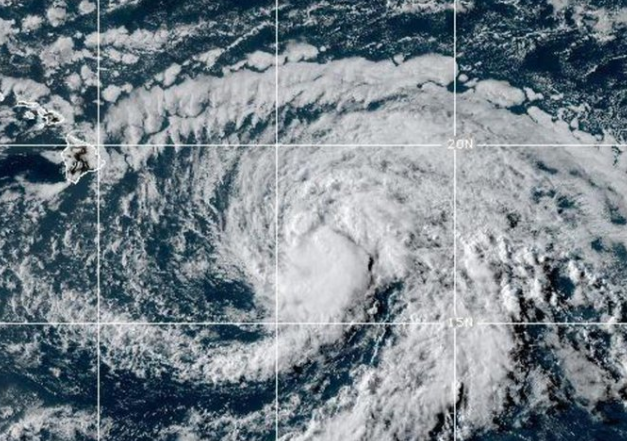
Tropical Storm Hone has developed in the central Pacific Ocean and is projected to approach Hawaii’s Big Island by late Saturday night or early Sunday morning. With maximum sustained winds of 50 mph, Hone is expected to strengthen over the next two days and could reach hurricane status by Sunday. The storm, which formed Thursday, is currently about 425 miles southeast of Hilo, Hawaii, moving west at 16 mph, according to the Central Pacific Hurricane Center.
Potential Impact on Hawaii:
- Rainfall: Hone could bring up to 10 inches of rain to the windward and southeast slopes of Hawaii’s Big Island between Saturday and Monday. Other smaller islands might receive up to 4 inches of rain.
- Surf and Rip Currents: The storm is anticipated to generate dangerous swells, potentially causing life-threatening surf and strong rip currents. A tropical storm watch has been issued for Hawaii County, which includes the Big Island.
Current Conditions:
- As of Friday evening, Hone is maintaining maximum sustained winds of 50 mph with higher gusts. Forecasters warn that the storm’s intensity is likely to increase, with a potential transition to hurricane status by Sunday.
Other Tropical Systems:
- Hurricane Gilma: Located about 1,750 miles east of Hilo, Hurricane Gilma is currently a Category 2 storm with sustained winds of 105 mph. Although it has weakened from a Category 3 major hurricane, it remains a powerful system. Gilma is moving west at 9 mph and is expected to remain a hurricane through the weekend, though it will likely continue to weaken.
The central Pacific hurricane season runs from June 1 to November 30, with the National Oceanic and Atmospheric Administration (NOAA) forecasting one to four tropical cyclones for the region this year, slightly below the average of four to five. A tropical cyclone becomes a tropical storm when its maximum sustained winds reach 39 mph and a hurricane at 74 mph.
No coastal warnings or watches are currently in effect for Hurricane Gilma. The system continues to move away from Hawaii and is not expected to pose a direct threat.
Residents of Hawaii should stay informed and prepared as Tropical Storm Hone approaches, and monitor updates from local weather authorities.
Key Points:
- Formation of Tropical Storm Hone:
- Tropical Storm Hone formed in the central Pacific on Thursday.
- The storm is projected to approach Hawaii’s Big Island by late Saturday night or early Sunday morning.
- Storm Intensity and Forecast:
- Hone has maximum sustained winds of 50 mph and could strengthen to a hurricane by Sunday.
- The storm is currently about 425 miles southeast of Hilo, Hawaii, moving west at 16 mph.
- Potential Impact on Hawaii:
- Rainfall: Up to 10 inches of rain expected on windward and southeast-facing slopes of the Big Island; up to 4 inches for smaller islands.
- Surf: Life-threatening surf and strong rip currents are likely due to swells generated by the storm.
- Tropical Storm Watch:
- A tropical storm watch is in effect for Hawaii County (Big Island).
- Other Tropical Systems:
- Hurricane Gilma: Located about 1,750 miles east of Hilo, Gilma is a Category 2 hurricane with maximum sustained winds of 105 mph.
- Gilma is expected to remain a hurricane through the weekend but is likely to weaken further.
- Central Pacific Hurricane Season:
- The season runs from June 1 to November 30.
- NOAA forecasts one to four tropical cyclones for the region this year, slightly below the average.
- No Coastal Warnings for Gilma:
- No coastal warnings are in effect for Hurricane Gilma, which is moving away from Hawaii.


